


CÁCH TẠO PHỐI CẢNH QUY HOẠCH, CẢNH QUAN, KIẾN TRÚC BẰNG AI

Updated: Sep 18
Chuyển ảnh google earth này thành ảnh 3D

Chuyển ảnh google earth này thành ảnh 3D có nổi các khối nhà lên, đây là 1 làng quê ở Việt Nam,CÁNH ĐỒNG SÔNG NƯỚC RUỘNG

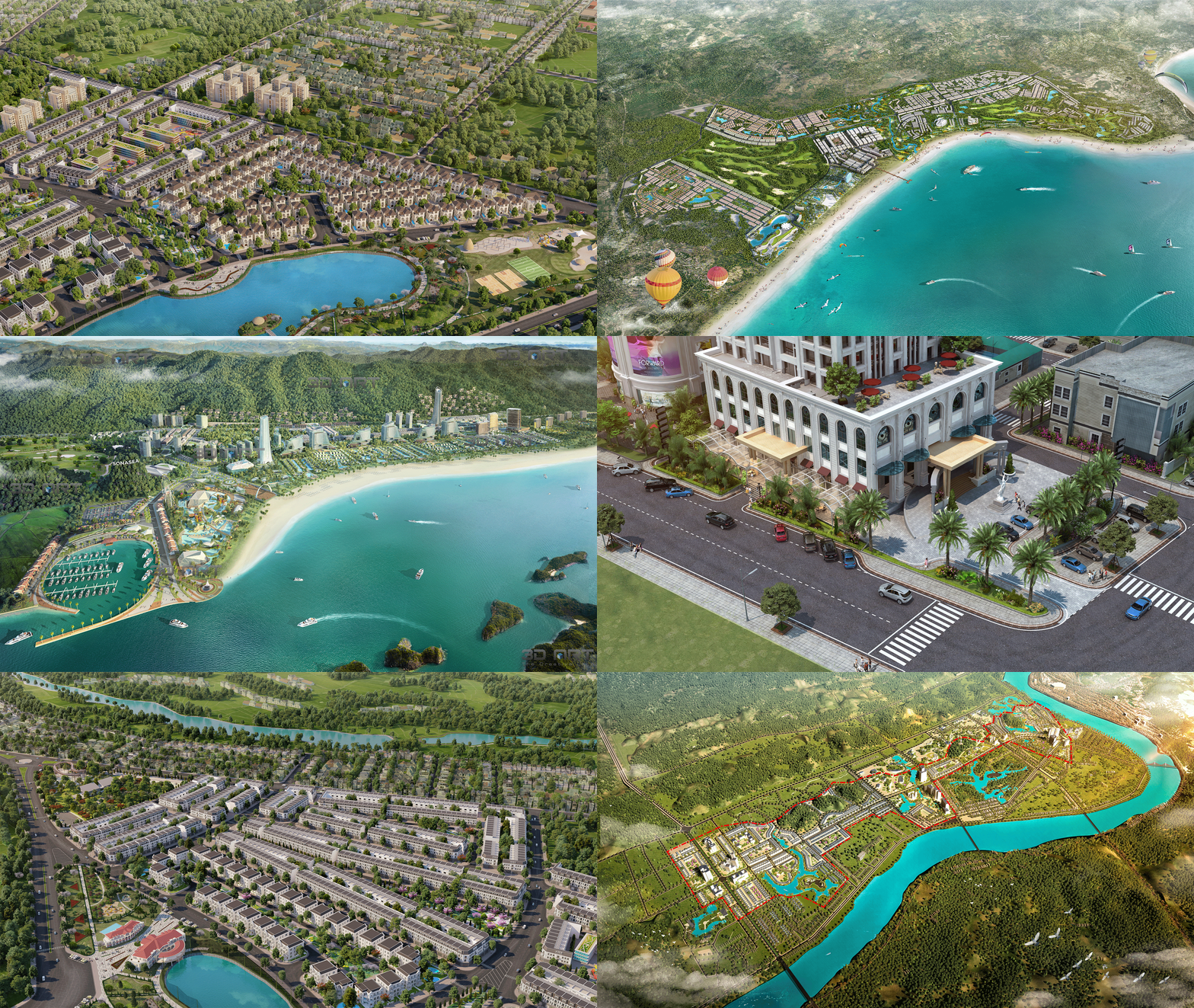
Dynamic aerial landscape (drone shot), perspective view, sharp focus, high quality, vast plain in the background, natural daylight lighting.Cảnh quan trên không sống động (quay bằng flycam), góc nhìn phối cảnh, lấy nét sắc nét, chất lượng cao, đồng bằng rộng lớn ở phía sau, ánh sáng ban ngày tự nhiên.CẢNG BIỂN BỜ BIỂN NÚI

Dynamic aerial landscape (drone shot), perspective view, sharp focus, harbor by the sea, mountains in the background, soft overcast light.Cảnh quan trên không sống động (quay bằng flycam), góc nhìn phối cảnh, lấy nét sắc nét, cảng biển, núi non phía xa, ánh sáng dịu nhẹ của mây mù.THIẾT KẾ 2D PLAN CẢNH QUAN


Thiết kế 2D pland cho lô đất này bao gồm: 1 công trình cafe hình chữ nhật, 1 hồ cá rộng, 1 cây cầu gỗ đi qua hồ cá và cây cối xung quanhGóc máy thấp cận cảnh, con đường lát sỏi, tập trung vào sự sắp đặt ngẫu nhiên mà hài hòa của từng viên đáHình ảnh phản chiếu của ngôi nhà foox gợn sóng nhẹ, màu sắc của cảnh vật trở nên lung linh, huyền ảo
GỢI Ý PROMPT:
Cảnh Trung (5)
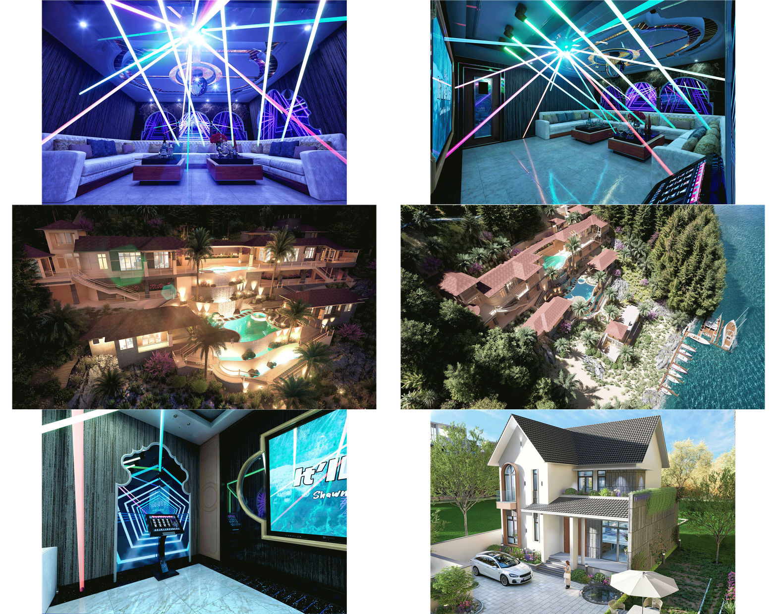
Toàn cảnh trung bình của bến du thuyền nhìn về phía những biệt thự ven biển, với những chiếc du thuyền sang trọng neo đậu trên mặt nước màu ngọc lục bảo.
Một góc nhìn trung cảnh khu vực hồ bơi và bãi biển riêng tư, với những chiếc ô che nắng và ghế dài, không khí nghỉ dưỡng thư thái.
Cảnh trung bình dọc theo một con đường nội khu rợp bóng cọ, dẫn đến các căn biệt thự mái ngói đỏ.
Góc chụp trung cảnh trên cây cầu nối liền hai khu của hòn đảo, phía xa là những tòa nhà và mặt nước lấp lánh.
Chụp trung cảnh sân hiên của một căn biệt thự, với bộ bàn ghế ngoài trời nhìn thẳng ra vịnh biển yên tĩnh.
Cảnh Cận (Nghệ thuật) (10)
Cận cảnh kết cấu của những viên ngói đất nung màu đỏ dưới ánh nắng vàng rực rỡ của buổi chiều.
Ảnh chụp macro những gợn sóng nước lăn tăn xung quanh thân một chiếc du thuyền màu trắng.
Góc máy thấp cận cảnh một cọc neo tàu màu vàng trên bến tàu, sử dụng hiệu ứng xóa phông để làm mờ những con thuyền phía sau.
Cận cảnh một tàu lá cọ đổ bóng sắc nét lên bức tường màu be của một căn biệt thự.
Chi tiết hình ảnh phản chiếu của những ngôi nhà và bầu trời trong xanh trên mặt nước tĩnh lặng của bến du thuyền.
Chụp cận cảnh bề mặt sàn gỗ của một cầu tàu, làm nổi bật các vân gỗ và kết cấu tự nhiên.
Một bông hoa nhiệt đới rực rỡ đang nở trong vườn, phía sau là kiến trúc của một biệt thự được làm mờ nhẹ.
Khung cảnh bến du thuyền với những chiếc thuyền buồm được nhìn qua một ô cửa sổ hoặc một mái vòm kiến trúc.
Bức ảnh nghệ thuật ghi lại khoảnh khắc ánh mặt trời lấp lánh trên mặt biển, tạo ra hiệu ứng bokeh lung linh.
TẠO KHỐI CHO BẢN ĐỒ

1. Áp dụng cho khu mật độ xây dựng cao/ nghiên nhiều về khu
nhà ở hiện hữu) :
Turn this image into an urban planning model. The base of the
model should be made of light brown walnut wood, featuring realistic and
hyper-details. The townhouses should be represented as 3D-printed
blocks, with trees crafted at a miniature scale. The water surface should
be made of epoxy resin, covered with a layer of clear acrylic. The model
must be presented in an isometric view against a white background for
easy post-processing and editing, and positioned at a 3/4 angle to clearly
reveal the details.
2. Áp dụng cho khu mật độ xây dựng thấp/ nghiêng về cảnh quan
nhiều hơn):
Turn this image into a Landscape architecture model. The base of
the model should be made of light brown walnut wood, featuring realistic
and hyper-details. The Grass mat for natural landscape, with trees crafted
at a miniature scale. Some houses should be represented as 3D-printed
simple boxes. The water surface should be made of epoxy resin, covered
with a layer of clear acrylic. The model must be presented in an isometric
view against a white background for easy post-processing and editing, and
positioned at a 3/4 angle to clearly reveal the details .
TẠO BẢN ĐỒ 3D

Create a high-resolution premium isometric 3D landscape and urban model of [TÊN KHU VỰC], [QUỐC GIA / TỈNH THÀNH].
Design it as a sophisticated standalone architectural landscape model with elegant floating Vietnamese information panels, combining geographic identity, urban structure, natural landscape, transportation systems, landmarks, and modern data visualization.
The image should feel like a high-end professional planning visualization of a real place, not a printed poster, not a fantasy map, and not a generic city model.
CORE OBJECTIVE:
Faithfully capture the unique spatial identity of [TÊN KHU VỰC].
Automatically analyze and visually represent the most recognizable real-world characteristics of this area, including:
- urban form
- terrain
- coastline / rivers / lakes / canals if present
- mountains / hills / valleys if present
- islands / bays / ports if present
- dense city blocks or low-density settlements depending on the actual area
- important roads, bridges, railways, metro lines, airports, ports when relevant
- parks, green belts, agricultural fields, wetlands, forests, or ecological zones when relevant
- iconic landmarks, heritage sites, tourism assets, administrative centers, business districts, industrial zones, or residential areas depending on the location
AREA TYPE ADAPTATION:
Adapt the model intelligently to the true character of [TÊN KHU VỰC]:
If it is a coastal city:
Emphasize the bay, beach line, waterfront boulevard, marina, islands, port areas, seaside parks, tourism skyline, and urban districts hugging the coastline.
If it is a river city or delta region:
Emphasize major rivers, canals, bridges, embankments, floodplains, waterfront communities, wetlands, boat routes, and the relationship between urban blocks and water systems.
If it is a mountain or highland region:
Emphasize mountain ranges, layered terrain, valleys, winding roads, plateaus, forests, waterfalls, lakes, and settlement clusters adapted to slopes.
If it is an island or archipelago:
Emphasize coastline, harbors, beaches, cliffs, island topography, resort zones, fishing villages, sea routes, coral or shallow-water color transitions when relevant.
If it is a historic or heritage area:
Emphasize old town structure, monuments, temples, citadels, traditional architecture, preservation zones, cultural landmarks, and historic street patterns.
If it is a modern metropolis:
Emphasize CBD skyline, dense urban blocks, high-rise clusters, transport hubs, arterial roads, riverside development, mixed-use districts, parks, and new urban areas.
If it is an industrial or logistics area:
Emphasize ports, warehouses, factories, container yards, logistics corridors, highways, rail or freight access, industrial blocks, and surrounding worker/residential zones.
If it is a rural, agricultural, or ecological landscape:
Emphasize fields, orchards, rice paddies, canals, village clusters, tree lines, wetlands, forests, aquaculture ponds, and low-rise settlement rhythm.
IMPORTANT REALISM:
The model must remain geographically believable and locally specific.
Do not invent unrelated landmarks.
Do not over-fantasize the terrain.
Do not turn the area into a futuristic city unless explicitly requested.
Maintain the correct relationship between water, land, roads, dense neighborhoods, open zones, and key landmarks.
COMPOSITION:
Use a clean angled isometric aerial view showing the entire area as a coherent 3D landscape model.
The composition should clearly reveal the main geographic structure first, then the built environment, then the landmarks and information panels.
The overall layout should feel balanced, elegant, premium, and easy to understand at a glance.
The model should have:
- a strong main visual axis based on the area’s real identity:
[river / coastline / mountain spine / urban boulevard / bay / heritage core]
- clear foreground, midground, and background depth
- detailed but not cluttered urban massing
- visibly distinct districts or functional zones
- soft atmospheric depth and refined shadows
INFORMATION PANELS:
Include clean floating Vietnamese information panels arranged elegantly around the model.
The panels should feel like a modern architectural visualization UI, not a printed infographic sheet.
MAIN TITLE:
“[TÊN KHU VỰC]”
SUBTITLE:
“Mô hình địa cảnh – đô thị – bản sắc không gian”
OPTIONAL CONTEXT LINE:
“[MÔ TẢ NGẮN 1 DÒNG VỀ KHU VỰC]”
EXAMPLE:
“Thành phố biển – du lịch – cảnh quan vịnh”
or
“Đô thị ven sông – thương mại – kết nối vùng”
or
“Vùng cao nguyên – sinh thái – du lịch nghỉ dưỡng”
LEGEND PANEL:
Create a clean panel titled:
“CHÚ GIẢI”
Automatically adapt the legend items to the area, selecting 8–10 suitable categories from this system:
- Mặt nước / Sông / Hồ / Vịnh biển
- Kênh rạch / Hành lang thủy hệ
- Bờ biển / Bãi biển
- Đồi núi / Địa hình tự nhiên
- Rừng / Vành đai xanh / Sinh thái
- Công viên / Không gian công cộng
- Khu đô thị hiện hữu
- Khu trung tâm thương mại
- Khu du lịch / Nghỉ dưỡng
- Khu công nghiệp / Cảng / Logistics
- Khu dân cư
- Khu di sản / Văn hóa
- Đường giao thông chính
- Cầu / Tuyến kết nối
- Đường sắt / Metro / Cáp treo if relevant
- Sân bay / Bến cảng if relevant
- Đất nông nghiệp / Vườn cây / Ruộng đồng if relevant
LANDMARK INDEX:
Add a refined panel titled:
“CÁC ĐỊA DANH QUAN TRỌNG”
Include 7–10 yellow numbered markers on the 3D map and a matching landmark index panel.
Each landmark item should have:
- Number
- Vietnamese landmark name
- Short one-line functional description
Structure:
1. [Địa danh 1] — [Mô tả ngắn]
2. [Địa danh 2] — [Mô tả ngắn]
3. [Địa danh 3] — [Mô tả ngắn]
4. [Địa danh 4] — [Mô tả ngắn]
5. [Địa danh 5] — [Mô tả ngắn]
6. [Địa danh 6] — [Mô tả ngắn]
7. [Địa danh 7] — [Mô tả ngắn]
8. [Địa danh 8] — [Mô tả ngắn]
9. [Địa danh 9] — [Mô tả ngắn]
Use subtle thin callout lines connecting the numbered yellow markers to the information panel when visually suitable.
OVERVIEW PANEL:
Add a clean panel titled:
“THÔNG TIN TỔNG QUAN”
Use concise informative labels adapted to the area, such as:
- Tính chất khu vực
- Cấu trúc không gian
- Cảnh quan chủ đạo
- Hệ sinh thái
- Giao thông kết nối
- Định hướng phát triển
- Vai trò du lịch / công nghiệp / đô thị / sinh thái
DEVELOPMENT PANEL:
Add a modern panel titled:
“ĐỊNH HƯỚNG PHÁT TRIỂN”
Include 4–5 concise Vietnamese bullet points suitable for the area, such as:
- Phát huy bản sắc không gian đặc trưng
- Tăng cường không gian xanh và sinh thái
- Kết nối giao thông – đô thị – du lịch
- Bảo tồn cảnh quan tự nhiên và di sản
- Phát triển bền vững, hài hòa giữa con người và địa hình
VISUAL STYLE:
Elegant architectural model visualization, premium urban and landscape rendering, minimalist but highly detailed.
The scene should look like a beautifully crafted contemporary planning model with crisp forms, refined material hierarchy, and subtle realism.
Use:
- sharp edges
- high-detail miniature city blocks
- clean landform sculpting
- realistic coastline / river edges / mountain contours
- detailed roads, bridges, green areas, and built forms
- soft sunlight and subtle shadows
- calm premium atmosphere
- strong clarity in spatial hierarchy
COLOR PALETTE:
Use a refined restrained palette:
- soft ivory
- pale beige
- light warm gray
- muted green
- desaturated blue / blue-gray for water
- gentle concrete tones
- small warm yellow numbered markers
- thin dark gray UI lines
- subtle pastel accents only when needed
BACKGROUND:
Very clean neutral background, minimal, airy, and unobtrusive.
The model should float naturally on a clean presentation plane without looking like a poster board.
RENDERING QUALITY:
Ultra-detailed, sophisticated architectural visualization, premium geographic model rendering, elegant composition, realistic yet art-directed, clean professional design language, sharp information hierarchy, high-end planning competition board quality, 8K detail.
IMPORTANT TEXT REQUIREMENT:
All information panel text must be written in Vietnamese.
Use correct Vietnamese diacritics.
Keep the text concise, readable, elegant, and professional.
AVOID:
- outer border
- page frame
- decorative frame
- printed paper texture
- museum sheet appearance
- physical poster board
- tabletop photography
- fabric background
- fantasy architecture
- sci-fi city
- exaggerated terrain
- inaccurate oversized landmarks
- random skyscrapers in low-rise areas
- cluttered composition
- oversaturated colors
- unreadable UI panels
- English text unless explicitly requested
- watermark
- logo
BỘ PROMPT CHO BỘ ẢNH CÔNG VIÊN HỒ
Góc máy từ phía sau, bắt trọn khoảnh khắc cô gái mặc áo dài trắng, tay cầm nón lá đang chậm rãi đi dạo trên nền đá bên trong vọng lâu. Bóng đổ của mái ngói in dài trên sàn, tạo nên những đường dẫn thị giác mạnh mẽ. Ánh sáng tương phản mạnh giữa vùng tối của mái hiên và vùng sáng rực rỡ của mặt hồ bên ngoàigóc chụp ngang tầm mắt Lối đi bộ uốn lượn ven hồ lát đá cubic màu xám xanh, ngăn cách với mặt nước bởi hàng rào sắt thấp tinh tế. , Ánh sáng hoàng hôn ấm áp, đổ bóng dàiẢnh chụp thực tế Master Plan view nhìn chim bay từ trên cao của một công viên đô thị hiện đại tại Việt Nam,
Tâm điểm là hồ điều hòa hình hạt đậu xanh biếc. Phong cách kiến trúc cảnh quan đương đại với đường dạo bộ uốn lượn ven hồ, thảm cỏ xanh mướt, quảng trường lát đá và hai lầu vọng cảnh mái ngói đỏ hình khối đa giác tinh tế.
Bối cảnh xung quanh là khu đô thị sầm uất với các tòa nhà cao tầng và dãy nhà phố đặc trưng của Hà Nội. Ánh sáng: Golden Hour rực rỡ, nắng vàng óng ả đổ bóng dài, tạo hiệu ứng Volumetric God Rays lung linh trên mặt nước. Góc máy: Toàn cảnh nhìn xuống mô phỏng góc chụp flycam, độ phân giải 8K, chân thực như ảnh chụp dự án thực tế., giữ đúng góc camera và chi tiết như ảnh tài liệu.Cô gái Việt Nam với nón lá truyền thống đang ngồi trên ghế đá dưới tán cây phượng vĩ xanh mát ven hồ. Ống kính 35mm tập trung vào sự giao thoa giữa con người và thiên nhiên. Ánh sáng lốm đốm (dappled light) xuyên qua tán lá đổ lên tà áo dài trắng, phía sau là mặt hồ gợn sóng lăn tăn.Góc chụp cận cảnh ngang tầm mắt nhìn từ mặt hồ hướng vào lầu bát giác, phản chiếu mờ mờ lầu bát giác xuống mặt nước, bố cục đối xứng, thời điểm hoàng hôn, ánh nắng ấm áp chiếu hắt lên mái nhà và lấp lánh mặt nướcMẸO PHÁT TRIỂN Ý TƯỞNG CẢNH QUAN CÔNG VIÊN BẰNG AI.
Thay vì để AI tự sáng tác hãy khoanh vùng chỉ định các hạng mục mong muốn như trong ảnh 2.
Prompt:
"Dựa trên ảnh chụp từ trên cao của công viên thể thao đô thị hiện trạng này, tiến hành thiết kế nâng cấp lần hai và cải thiện chất lượng không gian. Chỉ được phép cải tạo bên trong phạm vi khu đất công viên ở trung tâm hình ảnh.
Giữ nguyên tuyệt đối ranh giới khu đất hiện có, diện tích, vị trí và tỷ lệ tổng thể; không được mở rộng ra các tuyến đường, vỉa hè, công trình hoặc mảng xanh bên ngoài.
Toàn bộ các yếu tố xung quanh khu đất như công trình, đường giao thông, nút giao chữ thập, vạch qua đường, phương tiện, cây xanh đường phố, bối cảnh đô thị, hướng ánh sáng, vị trí camera flycam, quan hệ phối cảnh, tỷ lệ khung hình và kích thước ảnh đều phải giữ nguyên, không được thay đổi."





Comments